


By Cadasta’s Carolina Reynoso Pieters & Leah Kellenberger
Around the world, millions of people live, farm, and raise families on land to which they have no formal, recognized rights. These communities–Indigenous Peoples, smallholder farmers, women, and residents of informal settlements–face daily risks that undermine their livelihoods, limit their economic potential, and increase their vulnerability to climate shocks. Without documentation, people are effectively excluded from the legal and administrative systems that govern the land they depend on—limiting their ability to invest, adapt, or defend their rights.
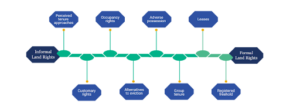
People cannot protect or benefit from their land without legal proof of occupation. For land rights to translate into lasting opportunity, communities and institutions must advance along the land rights continuum, from informal to legally recognized, enforceable tenure. This journey requires partnership, trust, and long-term commitment.
Moving Along the Land Rights Continuum
Tenure security is not binary. Most communities live somewhere between informal occupation and full legal recognition—and it is within this space that real progress, and real risk, exists. That is where Cadasta’s interventions can make a difference.
 Participatory mapping enables communities to document what they already know: where boundaries lie, how land is shared or inherited, and which places carry cultural or spiritual significance. GIS then translates this knowledge into standardized, georeferenced data that institutions recognize and can act on. GIS then translates this knowledge into standardized, georeferenced datasets that carry legitimacy with government institutions, courts, and other stakeholders. This strengthens local governance structures and ensures that documentation reflects broad community consent first. It also contributes to creating a defensible and accurate record of land use and occupation, which governments and formal land administration systems often require.
Each step toward formalization reduces vulnerability as:
- Women gain stronger protection against dispossession.
- Families become more likely to invest in their homes, farms, and businesses.
- Communities strengthen their negotiating power with governments or private actors.
- Local authorities improve planning, taxation systems, and service delivery.
- Climate resilience increases as communities invest in sustainable land and resource management.
Technology Alone Is Not the Solution: Partnership Is
Cadasta’s digital tools make the process of documenting tenure and resource rights easier, faster, and more inclusive. But technology alone cannot succeed. Durable tenure requires legal frameworks, community trust, institutional capacity, and political will. That is why Cadasta partners with organizations working at every level of the system:
- Grassroots groups who mobilize residents and bring deep local knowledge.
- Civil society organizations who provide legal aid, community engagement, and rights education.
- Government agencies who validate claims, integrate data into national systems, and formalize tenure.
- International development organizations who scale innovation, convene stakeholders, and align incentives.
Our role is to facilitate systems-level change. We work to strengthen partners so they can guide communities through their journey toward secure tenure and long-term prosperity.
Documentation Efforts in Belize and Suriname
To highlight the importance of accurate and inclusive GIS documentation, we look to two recent partnerships under Cadasta’s Strengthening Land and Forest Rights Program. In both Belize and Suriname, legal pathways to formal land rights for Indigenous Peoples do not yet exist. Our partnerships there speak to the importance of facilitating movement along the land continuum. These collaborations also demonstrate how community-led documentation and data systems can create a pathway for more inclusive legal frameworks.
Belize
In southern Belize, Cadasta collaborated with the Julian Cho Society (JCS) to map Maya communities’ rights. JCS, along with the Toledo Alcaldes Association (TAA) and the Maya Leaders Alliance (MLA), developed a partnership to strengthen land rights for the Maya people in line with the Caribbean Court of Justice’s (CCJ) Consent Order and international human rights standards. The CCJ 2015 consent order formally recognized and protected Maya customary land rights.
With fit-for-purpose tools and approaches, this project captured ethnographic data of six Maya communities over approximately 25,000 hectares of land. The partnership focused on building tools and workflows that could withstand the highest level of legal scrutiny—without compromising community ownership or control of the process. All data collection and monitoring activities were conducted with the community and led by the JCS/TAA/MLA. Cadasta’s tools were deployed to support the Maya land tenure system and make Indigenous data governance possible. The tools also worked to improve land management and economic development outcomes, including land use planning. Participating communities developed ethno-maps with technical support from the Cadasta team, capturing information on boundaries and historical usage from the villages.
JCS used the project’s maps and StoryMaps to present to two Ministers of Parliament in Belize. The presentation highlighted the Maya communities’ ongoing auto-delimitation efforts while providing clear evidence of the use, occupation, and enjoyment of their community lands. After the presentation, the Ministers made commitments to bring more awareness to the ongoing struggle of the Maya people in Southern Belize.
In March 2025, JCS submitted the ethno-maps produced through the project to the Caribbean Court of Justice as annexes of the litigation and implementation of the CCJ 2015 consent order. As highlighted by the judges, the maps provided a better understanding of the work that the Maya communities are undertaking. The Belizean government is working to provide legal pathways for Maya communities to use claim documents to strengthen the protection of their land. The work led by JCS, with technical support from Cadasta, now serves as concrete evidence of how participatory, community-led documentation can meet formal legal standards. The work in these projects is helping to pave the way for more accessible, inclusive, and equitable land administration systems.
Suriname
In 2007, the Inter-American Court of Human Rights mandated that the Government of Suriname stop logging and mining concessions in the Saamakas’ forest. The Court also ordered the Surinamese government to demarcate the Saamakas’ territory and legally recognise their collective ownership rights over the land. Yet still today, Indigenous and tribal peoples (ITP) in Suriname lack full legal recognition of their collective land and resource rights, and the government continues to give concessions to third parties. These concessions have now led to the damage and degradation of over 30% of the Saamaka forested territory. These actions have grave environmental consequences and threaten the survival of future generations in their ancestral lands.
Cadasta’s collaboration with the Association of Saamaka Communities (VSG) supported and strengthened the Saamaka’s capacity to monitor and document threats to the forest. The project coordinated with over 50 communities to begin a participatory mapping process. The team documented hunting and fishing areas, agricultural areas, trails, biodiversity reservoirs, and sacred places. This land use mapping strengthens Saamaka claims to land rights and titles; it also gives VSG more insight into actions that will help mitigate the ongoing effects of climate change.
The draft “Framework Law on the Collective Rights of Indigenous and Tribal Peoples,” submitted to Parliament in 2021, remains unapproved. In the absence of an approved legal framework, VSG’s mapping work is a proactive act of self-determination—creating a defensible record of territory, governance, and land use that can anchor future legal recognition. It creates a record of community territories that can later serve as evidence for legal recognition, strengthen governance, and provide protection against external pressures from mining, logging, and infrastructure expansion. Together, through capacity building, data sovereignty, and land use documentation, VSG and Cadasta are positioning Saamaka communities to respond effectively once the legal framework is enacted.
The Path Forward
As we look ahead, Cadasta will continue to:
- Expand technical support and training for partners.
- Support integration of community-generated data into government systems.
- Build evidence on how secure tenure drives climate resilience, gender equality, and economic growth.
- Innovate tools that meet partners where they are—robust enough for governments and intuitive enough for communities.
Cadasta’s work is not just about documenting land. It is about strengthening the systems that uphold rights—so communities are not merely recognized, but fully equipped to shape their own futures.
Progress along the land rights continuum is a collective journey. No organization can do it alone. But in combination with the right technology, partnerships, and community leadership, Cadasta can help unlock the benefits of land rights, ensuring that millions more people enjoy the security, dignity, and opportunity that land rights provide.