Why Land Systems Fail and How Uganda is Doing Things Differently

Apr 30 — 2026

By Wambayi Wabwire, Land Administration Advisor

Land underpins identity, livelihoods, and social stability. Yet across Uganda, where roughly 80 percent of land is held under customary tenure, the majority of people still lack formal recognition of their rights. Without documentation, families remain vulnerable to disputes, displacement, and the loss of ancestral land. 

This gap persists despite decades of legal and institutional progress. Uganda’s Constitution and Land Act recognize customary tenure, and significant investments have been made in national land systems. But in practice, those systems have not fully reflected how land is actually held and governed at the community level. 

This is not unique to Uganda. In many countries, land systems fail for predictable reasons. They are built around rigid technical standards, designed for formal tenure, and disconnected from how land is actually held and governed. As a result, they exclude the majority of landholders from recognition, even when legal frameworks exist to protect their rights. 

The result is a disconnect: systems exist, but they were not built for the communities they are meant to serve. 

The Limits of a One-Size-Fits-All System


Uganda’s customary tenure is rooted in community consensus and oral tradition. Yet the country’s National Land Information System (UgNLIS), developed with substantial international investment, has historically captured only a fraction of that land, focusing primarily on formal tenure types such as freehold and mailo.

Customary land makes up the majority of Uganda’s territory, but has remained largely invisible within the national system. As pressures on land increase from population growth, extractive industries, and large-scale acquisitions, the consequences of that invisibility become more pronounced. Recognition is not just a legal issue but also a concern for security, stability, and long-term stewardship.

Starting from Reality, Not Perfection

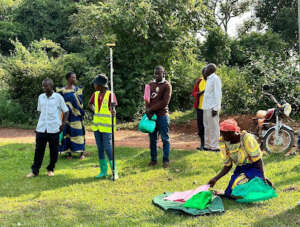
Addressing this challenge requires a shift in how land systems are designed. Rather than imposing rigid technical standards from the outset, a Fit-for-Purpose approach begins with a simple premise: systems should reflect how people relate to land.

They should be flexible, accessible, and capable of improving over time.

In practice, this means using boundaries that communities recognize, rather than requiring highly technical surveys from the start; relying on practical tools like aerial imagery and mobile data collection; focusing on accuracy that is sufficient; and building systems that can be updated and refined as needs evolve.

A System That Evolves Over Time


Uganda’s experience shows what this looks like in practice. 

Over the past two decades, the process of documenting customary land has evolved in phases. Initially, land boundaries were described verbally, based on local knowledge and physical markers. Later, hand-drawn sketch maps introduced a basic form of documentation. More recently, digital tools enabled communities to map their land using smartphones and tablets. Today, high-precision GNSS (Global Navigation Satellite System) tools allow community members themselves to capture land boundaries with remarkable accuracy. 

At each stage, the system was built on what came before, improving precision and reliability without abandoning community participation. What began as verbal agreements can now become formally recognized records. For many landholders, this is the first time their land has been formally recognized. 

This evolution has changed how land rights are understood and secured. Community members are actively involved in identifying and validating boundaries. Data is collected locally, often by trained community members and local committees. And once documented, land rights can move through a formal process toward recognition. 

The impact of this change is tangible, resulting in the issuance of thousands of Certificates of Customary Ownership (CCOs). These CCOs provide legal recognition to landholders who previously operated outside formal systems. At the same time, the data generated through this process can be integrated into the national land administration system, helping to bridge the gap between customary and formal land governance.

Accuracy Should Follow Purpose


One of the most important lessons from Uganda is that accuracy follows purpose, not the other way around. 

Efforts to document land did not begin with the highest possible technical standards. They began with what was needed to establish recognition. As that purpose expanded to include system integration, planning, and long-term management, accuracy improved accordingly. 

This challenges a common assumption that land systems must be technically perfect before they can be useful. In reality, starting with achievable standards can unlock progress that would otherwise stall.

Beyond Uganda: A Practical Path Forward


Uganda is not alone in facing these challenges. Across many countries, customary and informal land systems exist alongside formal frameworks that struggle to capture them. What Uganda demonstrates is not a one-size-fits-all solution, but a practical pathway: start with approaches that reflect how land is actually held, build trust and participation at the community level, and strengthen systems over time by improving accuracy, integration, and scale as capacity grows. 

Land systems do not fail when they lack technology; they fail when they do not reflect the reality on the ground. By prioritizing that reality over perfection, Uganda is showing what a more inclusive and adaptable approach to land governance can look like, one that is fit-for-purpose and capable of scaling globally. 

SHARE POST