
A Decade of Progress
Cadasta's Journey
A decade ago, Cadasta was founded on a simple but ambitious premise. Communities excluded from formal land systems could strengthen their rights by documenting their land on their own terms. What followed was a decade of learning, adaptation, and partnership that shaped Cadasta’s approach to supporting lasting land rights.
Early work demonstrated what participatory mapping could unlock. It also revealed the limits of technology alone. Secure land and resource rights depend on systems that can recognize community evidence, protect sensitive data, and translate local knowledge into legal and institutional outcomes.
Over time, Cadasta evolved in response. Strategic investments in platform capabilities, partner training, data governance, and institutional integration enabled the organization to move from isolated projects toward sustained impact at scale. Through periods of global disruption, including the COVID-19 pandemic and recent shifts in political and funding landscapes, Cadasta adapted its approach while deepening its focus on systems that operate across contexts and beyond individual projects.
As Cadasta enters its second decade, its impact reflects both scale and substance. Independent evidence shows that secure land rights reduce conflict, strengthen livelihoods, empower women, and support environmental stewardship. Just as importantly, the past ten years have clarified Cadasta’s role as a partner in strengthening land systems that better serve communities and governments.
A Decade of Impact
Cadasta's Ten-Year Evolution
2015–2017
Laying the Groundwork
Founded with support from Omidyar Network and DFID. Early pilot projects in participatory mapping. By 2017 480,000 people and 80,000 households documented.
2018–2019
A Strategic Pivot for Scale
Transitioned to Esri-based technology. First large-scale implementation in India. New CEO appointed. By 2019: 1.7 million people’s rights documented.
2020–2021
Resilience and Long-Term Vision
Adapted rapidly during COVID-19, onboarding 25 new partners, launching an online Training and Support Center. Cadasta sets a bold goal: secure land and resource rights for 500 million people by 2040.
2022–2024
Deepening Impact Through Partnerships
Expanded government and global alliance work. Nearly 180,000 formal land documents supported. More than 30 million hectares documented.
2025
Ten Years of Measurable Change
Cumulative impact reflects a decade of sustained partnership and learning, positioning Cadasta for its next phase of systems-level change.
Households Documented
People Documented
Hectares Mapped and Documented
A Decade of Impact
Cadasta by the Numbers
1.5M
Households Documented
7.24M
People Documented
7,000+
Communities Engaged
31.1M
Hectares Mapped and Documented
5.39M
Parcels Documented
182,000+
Official Land Documents Supported
145
Projects Implemented
108
Partner Organizations
Collaboration With
27
Government Partners
Work Conducted in
44
CountRies
*These metrics reflect cumulative impact since Cadasta’s founding through December 2025, and include work implemented in partnership with local, national, and global organizations.
A Decade of Impact
Cadasta's Projects
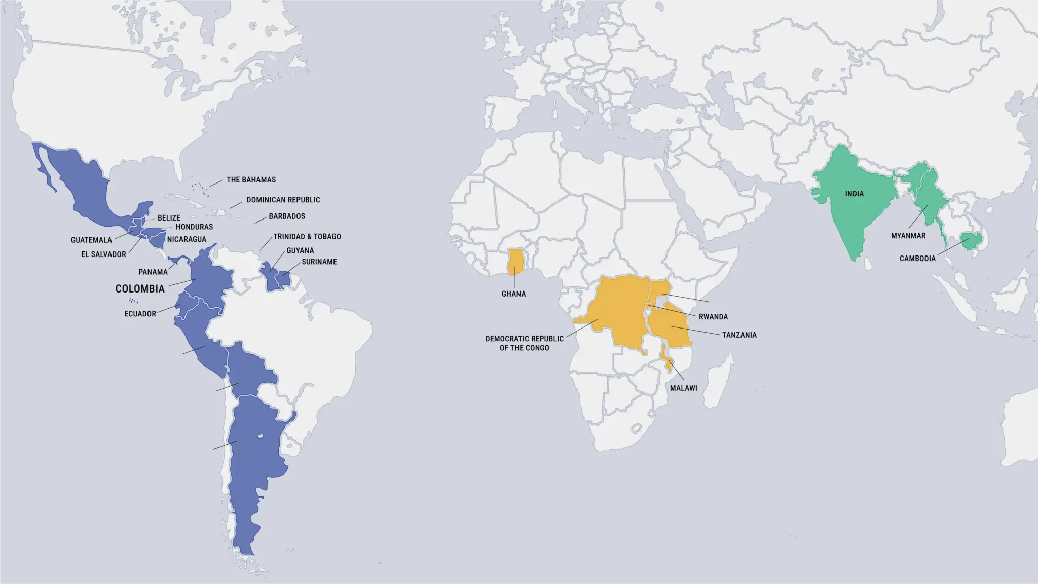
Countries Where Cadasta Supported Projects in 2025.
Caribbean
- Barbados
- Dominican Republic
- The Bahamas
- Trinidad and Tobago
Central America
- Belize
- El Salvador
- Guatemala
- Honduras
- Nicaragua
- Panama
North America
- Mexico
South America
- Argentina
- Bolivia
- Colombia
- Ecuador
- Guyana
- Peru
- Suriname
Sub-Saharan Africa
- Democratic Republic of the Congo
- Ghana
- Malawi
- Rwanda
- Tanzania
- Uganda
South Asia
- India
Southeast Asia
- Cambodia
- Myanmar
A Decade of Impact
Messages from Our Partners
For ten years, Cadasta has worked alongside partners to transform how land and resource rights are documented, understood, and protected. The voices below represent shared progress, trusted collaboration, and a collective commitment to ensuring communities have the information and tools they need.
Projects Implemented
Partner Organizations


