By Samuel Mboh, Program Specialist for West and Central Africa
In Equateur Province, Democratic Republic of the Congo (DRC), field engagement with partners from Solidarité pour la Promotion des Femmes Autochtones (SPFA) and local communities provided a clear view of how land governance and tenure security intersect with efforts to reduce deforestation.
One insight that stood out to me immediately: if we want projects to meaningfully reduce deforestation, we must first understand what is driving it at the local level.
Across the areas we discussed, four major drivers emerged: charcoal production, slash-and-burn agriculture, population growth, and both industrial and artisanal logging. These pressures vary by place, but they point to a shared reality. Securing land rights is essential, but on its own, it is not enough to protect forests over time.
Documentation is the foundation. What happens after matters just as much.
Where Maps Become Agreements
This became especially clear in Lokole village, in the Ntomba Nkole groupement, during a community-led map validation process.
What struck me was how deeply participatory the process was. The chef de groupement, chiefs and notables from neighboring villages, and the broader community—including women and children—all came together to review and validate the mapped boundaries.
The process culminated in the signing of the procès-verbal de validation des limites by the chef du groupement, the chiefs of all neighboring villages, and those who participated directly in the mapping process. On paper, this may seem procedural, but in practice, it was something much more meaningful. It was the movement where a map became a shared agreement.
Why Validation Matters
Reflecting on that moment, several things stood out. First, the validation process transforms technical outputs into something visible and collectively understood. A map alone carries information. A map that is publicly reviewed and agreed upon carries legitimacy.
Second, it helps prevent future conflict. In many contexts, disputes arise where boundaries are unclear or agreements remain informal. By validating boundaries publicly and documenting them together, communities reduce the risk of future contestation.
Third, it reinforces community legitimacy. Legal and procedural steps are important, but they are not sufficient on their own. Social recognition by neighboring communities and customary authorities is just as critical. A ceremony creates a moment where the community, neighboring villages, and customary authorities all acknowledge the result together.
Fourth, it strengthens institutional ownership. A public validation process helps move results from “project outputs” into documents recognized by the community and the authorities responsible for their long-term stewardship. It is a bridge from facilitation to local and institutional responsibility.
Finally, it preserves the memory of the agreement for present and future generations. What once existed only in oral tradition becomes documented, witnessed, signed, and much harder to contest.
Beyond Documentation
As I left Equateur, SPFA teams were continuing the same validation process in five other villages using this approach. What I found most encouraging is that this is not a one-time event. It is a replicable, community-led process that builds legitimacy, reduces conflict, and strengthens the foundation for long-term land and forest governance.
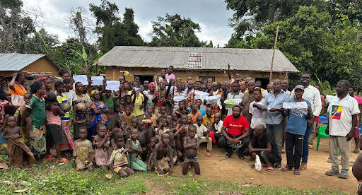
For me, Lokole was a powerful reminder that meaningful land and forest governance is built in community spaces, through dialogue, participation, and shared recognition. A map may be printed on paper, but its real strength comes from the people who gather around it, review it together, and say collectively that this is agreed, this is recognized, and this is how we move forward.


