


By Cadasta Staff
Typical conflict resolution strategies often require a mediator.
For Indigenous land-related conflicts and boundary validations, participatory mapping and technology can serve that role.
Participatory mapping is a community-led process in which local people lead the creation of maps that combine spatial knowledge and lived experience. It is a locally led process, often using teams within the communities chosen by customary authorities. Both technical and diplomatic, this process emphasizes collective validation and consensus by community members and neighbors. These maps incorporate local ecological knowledge, seasonal land use patterns, cultural and spiritual sites, and perceived boundaries to create rich, context-specific maps that represent real lived experiences.
Under Cadasta’s Strengthening Land and Forest Rights (SLFR) program, with support from UK International Development from the UK government, Cadasta worked with 13 partners across the major forest basins using participatory mapping techniques. These partnerships with Indigenous and local communities combined local community knowledge with high accuracy geospatial tools to solve land boundary disputes and meet the governments’ precision and accuracy requirements.
When Negotiating Boundaries, Community Knowledge Comes First
So how does participatory mapping act as a mediator?
It starts with the name. “Participatory” mapping involves a diverse mix of community members that bring their unique perspectives on territorial boundaries and land use. The process transmutes the lived knowledge of Indigenous peoples and local communities into fixed, mutually recognized data.
When paired with high accuracy field data collection tools, GIS platforms can overlay historical land use information, such as shared grazing routes or sacred sites, onto precise digital coordinates. This process eliminates ambiguity and gives the negotiating parties shared visual evidence rather than competing claims. The joint data collection and analysis process lays the foundation for resolving disputes and presenting a unified front against external threats.
Case Studies: Participatory Mapping from the Ground Up
Below are two use cases from our SLFR program that illustrate how participatory methods, when combined with technology, can prioritize local knowledge, solve conflicts, and secure tenure for communities. These examples show how participatory mapping shifts boundary negotiations from competing claims to shared evidence.
Case Study: Democratic Republic of the Congo (SPFA)
In the Equateur province in the DRC, Cadasta worked with grassroots organization Solidarité pour la Promotion des Femmes Autochtones (SPFA) and Commission Nationale de Réforme Foncière (CONAREF)– the DRC governing body that ensures land reform processes reflect the needs and rights of Congolese citizens– to assist local communities and Indigenous peoples in mapping their land holdings and obtaining government documents. 
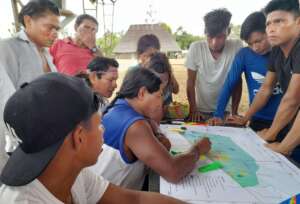
The work started in four villages in the Equator region by first conducting inclusive, village-wide consultations, better known as Free, Prior, and Informed Consent (FPIC), conducted in the local language. SPFA and Cadasta met with the main village chiefs, who invited key women and men from the community to learn about the project, ask any questions, and consent to participate. Following consent, village chiefs and their notables selected community data collectors based on their deep knowledge of the forest, land use, and the history of customary boundaries. Using the local language, SPFA and Cadasta trained these community data collectors on mapping, using GPS and tablets, and survey forms.
Before taking to the field, we consulted with neighboring communities in a joint session to ensure that they agreed with the designated boundaries. We begin simply by prompting the group to draw “mental maps” based on their shared memory and customary understanding. Then, alongside the selected community members, we recorded the preexisting boundaries by walking to the general boundary markers, such as rocks, trees, and other landmarks. Once confirmed, two data collectors from the main village walked the shared boundary with two people from the neighboring village. Together they collected the coordinates that shape their communities, ensuring that every point was validated in real time by representatives from both sides.
This participatory process ensured ongoing buy-in from both communities, offering various points in the process to review jointly for consensus. If a dispute arose during data collection, we recorded it and jointly reviewed with the chiefs and elders from both of the villages. Using the community charter and reference notes– key project inception documents kept by CONAREF– the communities involved in the dispute discussed their history together. By referencing historical records, documenting the area together, and consulting people with deep historical knowledge, we can work to resolve these disputes.
Our work with SPFA in the DRC illustrates the power of participatory mapping to invite conversations and consensus. By involving all relevant stakeholders and drawing diverse perspectives, the data we collect is, first and foremost, community-driven. Validated by the main village and all its neighboring communities, these maps have the potential to prevent further conflict by reflecting the villages’ lived experiences.
Case Study: Ecuador (CONFENIAE)
By integrating high-precision GIS with participatory mapping, Indigenous nations in the Ecuadorian Amazon are transforming decades of unclear boundaries into peace treaties.
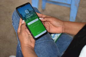
With co-funding from the Tenure Facility, Cadasta partnered with the Confederation of Indigenous Nationalities of the Ecuadorian Amazon (CONFENIAE) to strengthen Indigenous land governance and resolve long-standing territorial conflicts. CONFENIAE created Sistema de Información Territorial (SIT) CONFENIAE, a central hub that provides real-time data. The SIT data informs community decisions, supports conflict resolution, and strengthens land titling applications.
At times, participatory mapping is pitted against formal surveying methods that prioritize data precision, consistency, and replicability. But when paired with high-precision tools, participatory methods can meet the accuracy requirements of formal surveying processes. The project in Ecuador acquired real-time kinematic positioning (RTK) enabled devices– a high precision positioning technique that provides centimeter-level accuracy– and drone equipment. These technologies gave community monitors the tools to gather highly accurate geospatial data.
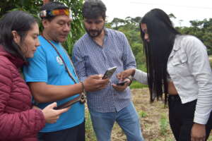
Equipped with the right technologies to complement Cadasta’s training on data collection and visualization, communities could then resolve overlapping claims across thousands of hectares, overlaying historical 1992 deeds onto real-time terrain imagery.
Indigenous groups from across the Ecuadorian Amazon participated in this project. Alongside a neighboring Shuar community, Saapap Entsa, an Achuar community located in the Ecuadorian Amazon, clarified critical hunting and fishing boundaries. In addition to solving conflicts, the mappers identified almost 200,000 hectares of Waroni territory still in conflict with Kichwa and Shuar communities, which will be the next priority. Clarifying these boundaries is a crucial step towards applying for formal titling.
In a landmark achievement, through this project, the Andwa and Shiwiar nationalities resolved a territorial conflict that had lasted more than two decades. Facilitated by CONFENIAE’s territory team and former territory leader Nanki Wampankit, the process included joint assemblies with representatives from nationalities across the Ecuadorian Amazonian. Community members conducted participatory mapping and jointly reviewed historical titles using the features to overlay multiple data sources on the SIT CONFENIAE platform.
Geospatial technologies and participatory methods provide the transparency needed to settle disputes that have lasted decades. By combining Indigenous and community knowledge with new, highly accurate technologies, we can protect territorial integrity with data that both communities and the state will hold with respect.
At the Intersection of Technology and Traditional Knowledge
Participatory mapping does more than document land. It changes how decisions are made. By grounding boundary negotiations in shared, verifiable data, participatory mapping shifts the process from competing claims to collective evidence.
Technology, when merged with community-led and traditional knowledge, can serve as an effective and neutral third party. Seeing the power of this confluence, the Strengthening Land and Forest Rights program built communities’ capacity to use technology to collect coordinates, conduct spatial analyses, and compare field data with historical records. The program, in teaching these uses of geospatial technology, ultimately enabled communities to agree upon territorial boundaries.
In the SLFR program, maps became more than just technical outputs.
Instead, they acted as impartial intermediaries, helping communities and their neighbors reach agreement based on what they can see, validate, and trust – together.